
Babaamaajimowinan (Telling of news in different places)
Babaamaajimowinan (Telling of news in different places)
Second of four district meetings with the next two in Redby znd Ponemah this week


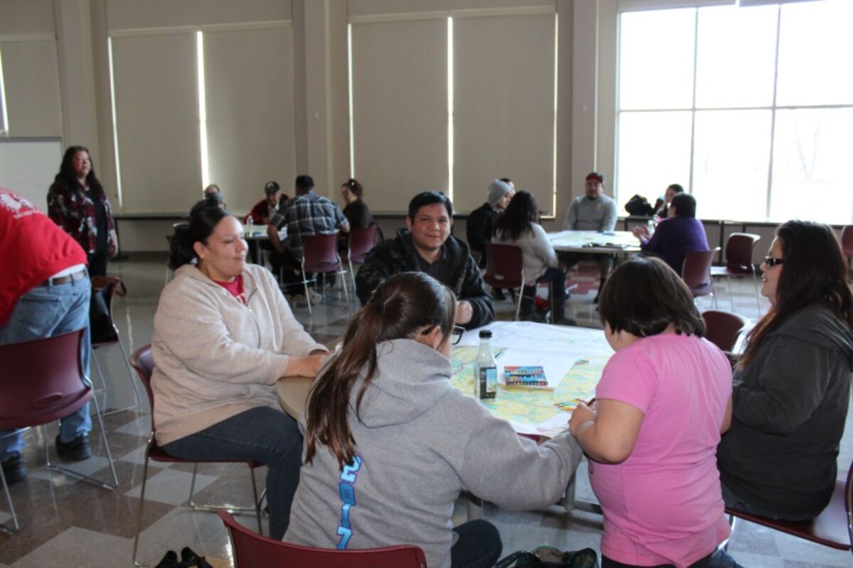


RED LAKE - The second of 4 district Land Use Planning Meetings was held for the Red Lake District at the Red Lake Nation College on Tuesday, April 4, 2017. A similar meeting took place in Littlerock on April 3rd.
After a soup and sandwich lunch and a 10-minute presentation by facilitator Sharon James, table discussions took place involving commercial/industrial/public building space, residential spaces, agricultural spaces and green spaces (parks/trails/recreational/protected areas.)
Some facts about the Red Lake Indian Reservation were also presented:
Total Acres: About 837,000 (680,000 acres diminished reservation)
Wetlands: 295,000 acres within diminished reservation
Lakes: 24,200 acres within diminished reservation
Protected Areas: 15,350 acres of DNR sensitive/managed areas
Developed Lands: About 900 acres
Titak Sqyare NukesL About 1,200 (about 1,060 diminished reservation)
Miles of Roads: 511 total miles of roads within diminished reservation
Number of Houses: about 2,250 houses and structures on the reservation
Red Lake District Data:
86 miles of road
358 acres previously developed
977 houses and structures (32.4 houses per mile)
110.2 people per square mile
5,000 acres of developable land
According to an article by Gary D. Taylor, Iowa State University, the comprehensive plan, also known as a general plan, master plan or land-use plan, is a document designed to guide the future actions of a community. It presents a vision for the future, with long-range goals and objectives for all activities that affect the local government. This includes guidance on how to make decisions on public and private land development proposals, the expenditure of public funds, availability of tax policy (tax incentives), cooperative efforts and issues of pressing concern, such as farmland preservation or the rehabilitation of older neighborhoods areas. Most plans are written to provide direction for future activities over a 10- to 20-year period after plan adoption. However, plans should receive a considered review and possible update every five years.
A community comprehensive plan serves the following functions:
The plan provides continuity. The plan provides continuity across time, and gives successive public bodies a common framework for addressing land-use issues.
It is the means by which a community can balance competing private interests. John Public may want to store oil drums on his property. Jane Citizen, his neighbor, would like to open a restaurant on her property. Planning seeks to strike a balance among the many competing demands on land by creating development patterns that are orderly and rational, provide the greatest benefits for individuals and the community as a whole and avoid nuisance conflicts between land uses.
It is the means by which a community can protect public investments. Planning is the means by which a community avoids digging up last year's new road to lay this year's new sewer pipe. Well-planned, orderly and phased development patterns are also less expensive for a community to provide with public services than low-density, scattered development.
It allows communities to plan development in a way that protects valued resources. Planning can identify environmental features like wetlands, agricultural lands, woods and steep slopes and suggest strategies for preserving those resources from destruction or degradation by inappropriate development.
It provides guidance for shaping the appearance of the community. A plan can set forth policies that foster a distinctive sense of place.
It promotes economic development. The plan contains valuable information that drives the location decisions of prospective firms.
It provides justification for decisions. Plans provide a factual and objective basis to support zoning decisions and can be used by communities to defend their decisions if challenged in court.
Through public dialogue, citizens express a collective vision for the future. Last, but certainly not least, the planning process provides citizens an opportunity to brainstorm, debate and discuss the future of their community. A plan developed through a robust public input process enjoys strong community support. Subsequent decisions that are consistent with the plan's policies are less likely to become embroiled in public controversy.
Large maps of the Red Lake District were provided to each table and discussions and ideas were presented and documented. Those ideas would be presented to the Red Lake Tribal Council once all the meetings were held and the information was compiled.
A similar meeting will take place in Redby on Wednesday, April 5, and another meeting was scheduled for Ponemah on Thursday, April 6th.
For more information on the Land Use Planning Team, you can call 679-1456 or 1460.
Following this article, RLNN will publish sections of the "Transportation and Land Use Plan for the Red Lake Reservation", which is a working draft submitted by the Economic Development Department in June 2009.


Reader Comments(0)